|
Israel
Petah-Tikva Centenary
1978 Bronze Medal 60mm (97.21 grams)
Stylistic tree, ancient arch, wheelbarrow, agricultural tools.
1977-8 100 PETAH-TIKVA CENTENARY, Coat-of-Arms left with olive branch and hanging olives.
You are bidding on the exact item pictured, provided with a Certificate of Authenticity and Lifetime Guarantee of Authenticity.
 Petah Tikva (Hebrew: פֶּתַח תִּקְוָה, lit. ’Opening of Hope’), also known as Em HaMoshavot (lit. ’Mother of the Moshavot‘), is a city in the Central District of Israel, 10.6 km (6.6 mi) east of Tel Aviv. It was founded in 1878, mainly by Ultra-Orthodox Jews of the Old Yishuv, and became a permanent settlement in 1883 with the financial help of Baron Edmond de Rothschild. Petah Tikva (Hebrew: פֶּתַח תִּקְוָה, lit. ’Opening of Hope’), also known as Em HaMoshavot (lit. ’Mother of the Moshavot‘), is a city in the Central District of Israel, 10.6 km (6.6 mi) east of Tel Aviv. It was founded in 1878, mainly by Ultra-Orthodox Jews of the Old Yishuv, and became a permanent settlement in 1883 with the financial help of Baron Edmond de Rothschild.
In 2019, the city had a population of 247,956. Its population density is approximately 6,277 inhabitants per square kilometre (16,260/sq mi). Its jurisdiction covers 35,868 dunams (~35.9 km2 or 15 sq mi). Petah Tikva is part of the Tel Aviv Metropolitan Area.
The place where Petah Tikva was founded existed as a village for a long time, immediately previously as a village called Mulabbis.
Khirbat Mulabbis is believed to have been built on the site of the Crusader village of Bulbus, an identification proposed in the nineteenth century by French scholar J. Delaville Le Roulx.(fr) A Crusader source from 1133 CE states that the Count of Jaffa granted the land to the Hospitaller order, including “the mill/mills of the three bridges” (“des moulins des trios ponts”).
In 1478 CE (883 AH), the Mamluk Sultan of Egypt, Qaitbay, endowed a quarter of the revenues of Mulabbis to two newly established institutions: Madrasa Al-Ashrafiyya in Jerusalem, and a mosque in Gaza.
It has been suggested that Mulabbis was Milus, a village with 42 Muslim households, mentioned in the Ottoman tax records in 1596.
The village appeared under the name of Melebbes on Jacotin’s map drawn-up during Napoleon’s invasion in 1799, while it was called el Mulebbis on Kiepert’s map of Palestine published in 1856. The village was repopulated following Ibrahim Pasha of Egypt’s expedition to the Levant (1831-1841) by Egyptian emigrants belonging to the Abu Hamed al-Masri Clan, as part of a wider wave of migration that settled in Palestine’s coastal lowlands.
In 1870 Victor Guérin noted that Melebbes was a small village with 140 persons, surrounded by fields of watermelon and tobacco. An Ottoman village list from about the same year showed that Mulebbes had 43 houses and a population of 125, though the population count included men, only. It was also noted that the village was located on a hill, (Auf einer anhöhe”), 2 3/4 hours NE of Jaffa.
The Palestine Exploration Fund’s Survey of Western Palestine visited Mulebbis in 1874 and described it as “a similar mud village -Mirr], with a well.” Following the sale of Mulabbis’ lands to Jewish entrepreneurs, its residents dispersed in neighboring villages like Jaljulia and Fajja.
Petah Tikva was founded in 1878 by ultra-orthodox Jewish pioneers from Europe, among them Yehoshua Stampfer, Moshe Shmuel Raab, Yoel Moshe Salomon, Zerach Barnett, and David Gutmann, as well as Lithuanian Rabbi Aryeh Leib Frumkin who built the first house. It was the first modern Jewish agricultural settlement in Ottoman Southern Syria (hence its nickname as “Mother of the Moshavot”).
Originally intending to establish a new settlement in the Achor Valley, near Jericho, the pioneers purchased land in that area. However, Abdülhamid II cancelled the purchase and forbade them from settling there, but they retained the name Petah Tikva as a symbol of their aspirations.
In 1878 the founders of Petah Tikva learned of the availability of land northeast of Jaffa near the village of Mulabes (or Umlabes). The land was owned by two Christian businessmen from Jaffa, Antoine Bishara Tayan and Selim Qassar, and was worked by some thirty tenant farmers. Tayan’s property was the larger, some 8,500 dunams, but much of it was in the malarial swamp of the Yarkon Valley. Qassar’s property, approximately 3,500 dunams, lay a few kilometers to the south of the Yarkon, away from the swampland. It was Qassar’s that was purchased on July 30, 1878. Tayan’s holdings were purchased when a second group of settlers, known as the Yarkonim, arrived in Petah Tikva the following year. Ottoman Sultan Abdul Hamid II allowed the purchase because of the poor quality of the land.
A malaria epidemic broke out in 1880, forcing the abandonment of the settlements on both holdings. Those who remained in the area moved south to Yehud. After Petah Tikva was reoccupied by Bilu immigrants in 1883 some of the original families returned. With funding for swamp drainage provided by Baron Edmond de Rothschild, the colony became more stable.
Upon learning that the Austrian post office in Jaffa wanted to open a branch in Petah Tikva, Yitzchak Goldenhirsch, an early resident, offered his assistance on condition that the Austrian consulate issued a Hebrew stamp and a special postmark for Petah Tikva. The stamp was designed by an unknown artist featuring a plow, green fields and a blossoming orange tree. The price was 14 paras (a Turkish coin) and displayed the name ‘Petah Tikva’ in Hebrew letters.
David Ben Gurion (then known as David Grün) lived in Petah Tikva for a few months on his arrival in Palestine in 1906. It had a population of around 1000, half of them farmers. He found occasional work in the orange groves. But he soon caught malaria and his doctor recommended he return to Europe. The following year, after moving to Jaffa, he set up a Jewish workers organisation in Petah Tikva.
During the Sinai and Palestine Campaign of World War I, Petah Tikva served as a refugee town for residents of Tel Aviv and Jaffa, following their exile by the Ottoman authorities. The town suffered heavily as it lay between the Ottoman and British fronts during the war.
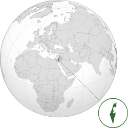
 Israel (Hebrew: יִשְׂרָאֵל), officially the State of Israel, is a country in the Middle East, on the southeastern shore of the Mediterranean Sea and the northern shore of the Red Sea. It has land borders with Lebanon to the north, Syria to the northeast, Jordan on the east, the Palestinian territories of the West Bank and Gaza Strip to the east and west, respectively, and Egypt to the southwest. The country contains geographically diverse features within its relatively small area. Israel’s economic and technological center is Tel Aviv, while its seat of government and proclaimed capital is Jerusalem, although the state’s sovereignty over Jerusalem has only partial recognition. Israel (Hebrew: יִשְׂרָאֵל), officially the State of Israel, is a country in the Middle East, on the southeastern shore of the Mediterranean Sea and the northern shore of the Red Sea. It has land borders with Lebanon to the north, Syria to the northeast, Jordan on the east, the Palestinian territories of the West Bank and Gaza Strip to the east and west, respectively, and Egypt to the southwest. The country contains geographically diverse features within its relatively small area. Israel’s economic and technological center is Tel Aviv, while its seat of government and proclaimed capital is Jerusalem, although the state’s sovereignty over Jerusalem has only partial recognition.

Israel has evidence of the earliest migration of hominids out of Africa. Canaanite tribes are archaeologically attested since the Middle Bronze Age, while the Kingdoms of Israel and Judah emerged during the Iron Age. The Neo-Assyrian Empire destroyed Israel around 720 BCE. Judah was later conquered by the Babylonian, Persian and Hellenistic empires and had existed as Jewish autonomous provinces. The successful Maccabean Revolt led to an independent Hasmonean kingdom by 110 BCE, which in 63 BCE however became a client state of the Roman Republic that subsequently installed the Herodian dynasty in 37 BCE, and in 6 CE created the Roman province of Judea. Judea lasted as a Roman province until the failed Jewish revolts resulted in widespread destruction, expulsion of Jewish population and the renaming of the region from Iudaea to Syria Palaestina.[34] Jewish presence in the region has persisted to a certain extent over the centuries. In the 7th century the Levant was taken from the Byzantine Empire by the Arabs and remained in Muslim control until the First Crusade of 1099, followed by the Ayyubid conquest of 1187. The Mamluk Sultanate of Egypt extended its control over the Levant in the 13th century until its defeat by the Ottoman Empire in 1517. During the 19th century, national awakening among Jews led to the establishment of the Zionist movement in the diaspora followed by waves of immigration to Ottoman and later British Palestine.
 In 1947, the United Nations adopted a Partition Plan for Palestine recommending the creation of independent Arab and Jewish states and an internationalized Jerusalem. The plan was accepted by the Jewish Agency, and rejected by Arab leaders. The following year, the Jewish Agency declared the independence of the State of Israel, and the subsequent 1948 Arab-Israeli War saw Israel’s establishment over most of the former Mandate territory, while the West Bank and Gaza were held by neighboring Arab states. Israel has since fought several wars with Arab countries, and it has since 1967 occupied territories including the West Bank, Golan Heights and the Gaza Strip (still considered occupied after 2005 disengagement, although some legal experts dispute this claim).[41][42][43][fn 4] It extended its laws to the Golan Heights and East Jerusalem, but not the West Bank. Israel’s occupation of the Palestinian territories is the world’s longest military occupation in modern times.[fn 4][49] Efforts to resolve the Israeli-Palestinian conflict have not resulted in a final peace agreement. However, peace treaties between Israel and both Egypt and Jordan have been signed. In 1947, the United Nations adopted a Partition Plan for Palestine recommending the creation of independent Arab and Jewish states and an internationalized Jerusalem. The plan was accepted by the Jewish Agency, and rejected by Arab leaders. The following year, the Jewish Agency declared the independence of the State of Israel, and the subsequent 1948 Arab-Israeli War saw Israel’s establishment over most of the former Mandate territory, while the West Bank and Gaza were held by neighboring Arab states. Israel has since fought several wars with Arab countries, and it has since 1967 occupied territories including the West Bank, Golan Heights and the Gaza Strip (still considered occupied after 2005 disengagement, although some legal experts dispute this claim).[41][42][43][fn 4] It extended its laws to the Golan Heights and East Jerusalem, but not the West Bank. Israel’s occupation of the Palestinian territories is the world’s longest military occupation in modern times.[fn 4][49] Efforts to resolve the Israeli-Palestinian conflict have not resulted in a final peace agreement. However, peace treaties between Israel and both Egypt and Jordan have been signed.
In its Basic Laws, Israel defines itself as a Jewish and democratic state. Israel is a representative democracy[neutrality is disputed] with a parliamentary system, proportional representation and universal suffrage. The prime minister is head of government and the Knesset is the legislature. Israel is a developed country and an OECD member, with the 32nd-largest economy in the world by nominal gross domestic product as of 2017. The country benefits from a highly skilled workforce and is among the most educated countries in the world with one of the highest percentages of its citizens holding a tertiary education degree. Israel has the highest standard of living in the Middle East, and has one of the highest life expectancies in the world.
|


 Petah Tikva (Hebrew: פֶּתַח תִּקְוָה, lit. ’Opening of Hope’), also known as Em HaMoshavot (lit. ’Mother of the Moshavot‘), is a city in the Central District of Israel, 10.6 km (6.6 mi) east of Tel Aviv. It was founded in 1878, mainly by Ultra-Orthodox Jews of the Old Yishuv, and became a permanent settlement in 1883 with the financial help of Baron Edmond de Rothschild.
 Israel (Hebrew: יִשְׂרָאֵל), officially the State of Israel, is a country in the Middle East, on the southeastern shore of the Mediterranean Sea and the northern shore of the Red Sea. It has land borders with Lebanon to the north, Syria to the northeast, Jordan on the east, the Palestinian territories of the West Bank and Gaza Strip to the east and west, respectively, and Egypt to the southwest. The country contains geographically diverse features within its relatively small area. Israel’s economic and technological center is Tel Aviv, while its seat of government and proclaimed capital is Jerusalem, although the state’s sovereignty over Jerusalem has only partial recognition.
 In 1947, the United Nations adopted a Partition Plan for Palestine recommending the creation of independent Arab and Jewish states and an internationalized Jerusalem. The plan was accepted by the Jewish Agency, and rejected by Arab leaders. The following year, the Jewish Agency declared the independence of the State of Israel, and the subsequent 1948 Arab-Israeli War saw Israel’s establishment over most of the former Mandate territory, while the West Bank and Gaza were held by neighboring Arab states. Israel has since fought several wars with Arab countries, and it has since 1967 occupied territories including the West Bank, Golan Heights and the Gaza Strip (still considered occupied after 2005 disengagement, although some legal experts dispute this claim).[41][42][43][fn 4] It extended its laws to the Golan Heights and East Jerusalem, but not the West Bank. Israel’s occupation of the Palestinian territories is the world’s longest military occupation in modern times.[fn 4][49] Efforts to resolve the Israeli-Palestinian conflict have not resulted in a final peace agreement. However, peace treaties between Israel and both Egypt and Jordan have been signed.

