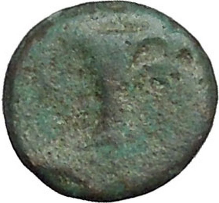
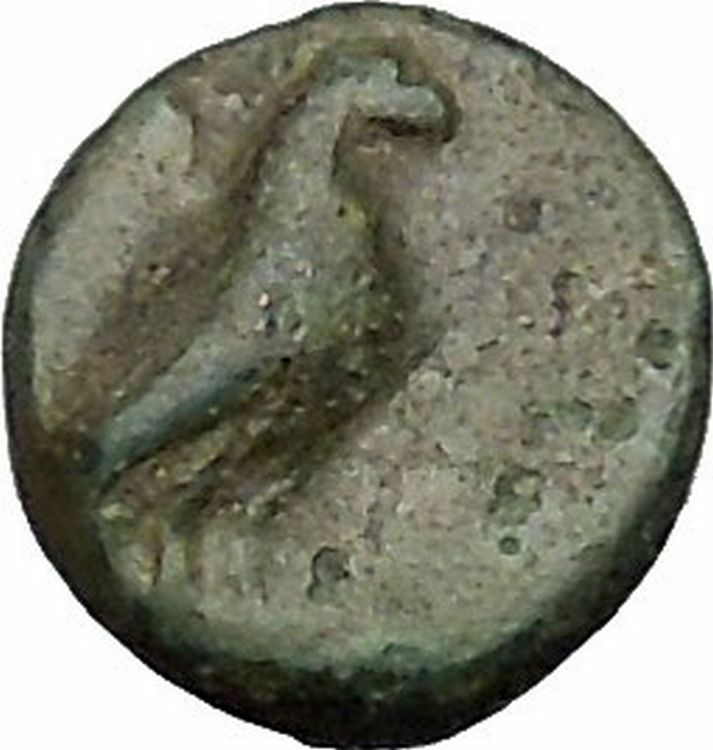
|
Greek city of
Aigeai in
Cilicia
Pseudo-autonomous issue
Bronze 17mm (3.64 grams) Struck 34/33 B.C.
Reference: Sear 5518; SNG Levante 1685; H.-J. Bloesch, “Hellenistic coins of
Aegeae (Cilicia),” in ANSMN 27 (1982), 248
Diademed head of Alexander the Great right.
ΑΙΓЄ / AIΩΝ /
ΔΙ (=year14 of Caesarean era = 34/33 B.C.), Nike advancing left, holding
wreath and palm, MH monogram in field to right.
It is possible that this coin was meant to commemorate the 300th year
anniversary of Alexander the Great’s famous victory at Issos in 333 B.C.
A town of eastern Cilicia, Aigeai
was situated on the the north-western shores of the Gulf of Issos.
You are bidding on the exact
item pictured, provided with a Certificate of Authenticity and Lifetime
Guarantee of Authenticity.
The Battle of Issus occurred in southern
Anatolia
, in November 333 BC between the
Hellenic League
led by
Alexander the Great
and the
Achaemenid
Persia
, led by
Darius III
, in the second great battle of
Alexander’s conquest of Asia. The invading Macedonian troops defeated Persia.
After the Hellenic League soundly defeated the Persian
satraps
of
Asia Minor
(led by the Greek mercenary,
Memnon of Rhodes
) at the
Battle of the Granicus
, Darius took personal
command of his army. He gathered reinforcements and led his men in a surprise
march behind the Hellenic advance to cut their line of supply. This forced
Alexander to countermarch, setting the stage for the battle near the mouth of
the Pinarus River
and the town of
Issus
.
The battle of Issus by
Jan Brueghel the Elder
in
the Louvre
.
Location
The battle took place south of the ancient town
Issus
, which is close to present-day
Turkish
town of
Iskenderun
(the
Turkish
equivalent of “Alexandria”, founded by
Alexander
to commemorate his victory), on
either side of a small river called
Pinarus
. At that location the distance from the
Gulf of Issus
to the surrounding mountains is
only 2.6 km (2 mi), a place where Darius could not take advantage of his
superiority in numbers. Speculation on the location of the Pinarus has taken
place for over 80 years. Older historians believed it to be the
Deli Tchai
river, but historians N.G.L. Hammond
and A.M. Devine have made convincing claims that the Pinarus is actually the
Payas River
, the latter using eye-witness
examination of the river, which may not have drastically changed since
antiquity. Their evidence is based on
Callisthenes
‘ accounts of the measurements of
the battlefield and distances marched by both side’s armies in the prelude to
the battle and distance given by
Diodorus
after the battle.
Background
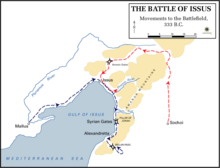
Movements to the battlefield.
Alexander set out into Asia in 334 BC and defeated the local Persian
satraps
at the
Battle of the Granicus
. He then proceeded to
occupy all of Asia Minor, with the idea of capturing all coastal settlements so
as to negate the power of the vastly superior Persian fleet. He captured several
important settlements such as
Miletus
in 334 BC and
Halicarnassus
, a siege lasting four months,
starting in late December the same year. While Alexander was in
Tarsus
he heard of Darius massing a great army
in Babylon
. If Darius were to reach the Gulf of
Issus he could use the support from the Persian fleet under
Pharnabazus
still operating in the
Mediterranean Sea
, thus easing his supply and
possibly landing troops behind the enemy. Alexander kept his main army at Tarsus
but sent Parmenion
ahead to occupy the coast around
Issus. In November, Alexander received reports that the great Persian army had
advanced into Syria, to a town named Sochi. Alexander decided to mass his
scattered army and advance south from Issus through the Pass of Jonah.
Darius knew that Parmenion held the Pass of Jonah and thus chose a northern
route of advance. The Persians captured Issus without opposition, and cut off
the hands of all the sick and wounded that Alexander had left behind. Now Darius
found out he had placed his army behind the Hellenic League and had cut their
supply lines. He then advanced to the south and got no further than the river
Pinarus before his scouts spotted Alexander marching north. Darius had to set up
camp on this narrow coastal plain.
Motives
Initial dispositions of Persian and Macedonian forces.
There is much debate as to the motives of Alexander and Darius preceding
Issus. A strong and convincing modern perspective, based on
Curtius
, is that Darius was forced to move camp
to terrain that favored Alexander because Alexander was fighting defensively due
to a recommendation by his war council and
Parmenion
. Darius’ large army could not be
supported in the field during winter and his cities in
Phoenicia
were already in unrest at the arrival
of Alexander. Darius was forced to move his large army to a small battlefield,
greatly to the advantage of Alexander’s smaller force.
Alexander was waiting for Darius to come south around the Amanus Mountain
range because the pass Darius would have used, the
Belen Pass
, was much closer to Sochi and
offered the quickest access to the area Alexander defended. Alexander was
waiting 15 km (9.3 mi) to the west of the Belen Pass at
Myriandrus
to spring a trap on Darius as he
crossed through the Belen Pass or through the Pillar of Jonah if he moved north,
where Darius’ army would be disorganized and disjointed in the narrow crossing.
Darius instead moved north from Sochi and around the mountains, emerging behind
Alexander’s position and on his supply and communication lines. Thus Alexander
was forced to march to Darius, who had caught him off guard in a large flanking
maneuver. This gives the illusion that Darius was the one acting defensively,
since Alexander was forced to march to him.
Combatants
Persian army
Some ancient sources (Arrian
and Plutarch
), who based their accounts on earlier
Greek sources, estimated 600,000 Persian soldiers in total, while
Diodorus
and
Justin
estimated 400,000, and
Curtius Rufus
estimated 250,000.
Modern historians find
Arrian
‘s count of six hundred thousand men
highly unlikely. They argue that the
logistics
of fielding more than 100,000
soldiers in battle was extremely difficult at the time.
Hans Delbrück
gives an estimate as small as
25,000, although most (including Engels and
Green
) estimate the total size of Darius’ army
to be no larger than 100,000 at Issus, including 11,000 cavalry, 10,000
Persian Immortals
, and 10,000 Greek
mercenaries. Warry estimates 108,000 in total.
Hellenic army
The size of the Hellenic army may not have exceeded 40,000 men, including
their other allies, led by Alexander. Alexander’s army may have consisted of
about 22,000
phalangites
and
hoplites
, 13,000
peltasts
, and 5,850
cavalry
.[2]
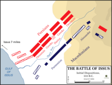
Battle
The Greeks advanced through the Pillar of Jonah. Alexander led his
Companion cavalry
on the right flank and he set
his Thessalian allied cavalry on the left of the
phalanx
with
Parmenion
in command.
Darius formed his line with his heavy cavalry concentrated next to the coast
on his right, followed by the Greek mercenary phalanx (historian A.M Devine
places them at a strength of 12,000, comparable to Alexander’s Greek phalanx).
Next to the Greek phalanx Darius spread his Persian infantry, the
Cardaces
, along the river and into the
foothills, where they wrapped around to the other bank and threatened
Alexander’s right flank (the formation resembled gamma, Γ).
Arrian
gives an inflated figure of 20,000 to
these troops. Darius positioned himself in the centre with his best infantry,
the Greek mercenaries, and his royal cavalry guard. According to some
historians, like P. Stratikis, he was trying to replicate the Hellenic battle
formation of the
Battle of the Granicus
.
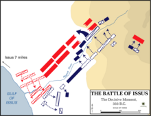
Alexander
‘s decisive attack.
The Persian cavalry first charged Parmenion and the allied cavalry, crossing
the river to open battle. Alexander’s left wing became the crux of the battle,
as at
Gaugamela
two years later, where Parmenion held
the wing long enough against superior Persian numbers for Alexander to make his
calculated cavalry strike against Darius and break the Persian army. The
Hypaspists
led by Alexander, on foot, delivered
an assault during this time across the riverbed on the Cardaces and managed to
punch a hole through the Persian line.
Alexander then mounted a horse at the head of his
Companion cavalry
and led a direct assault
against Darius who fled from the battlefield. Alexander then saw his left flank
and center in trouble, let Darius flee, and crashed into the rear of the Greek
mercenaries. The Greek mercenaries broke up. The Persians saw that their Great
King had gone and that the battle was being lost, and they abandoned their
positions and fled in full rout. The Hellenic cavalry pursued the fleeing
Persians for as long as there was light. As with most ancient battles,
significant carnage occurred after the battle as pursuing Greeks slaughtered
their crowded, disorganized foe.
Arrian
notes that
Ptolemy I
mentions that, while pursuing Darius,
Alexander and his bodyguards came upon a gap which they easily crossed on the
bodies of dead Persians. It was a decisive victory for Alexander.
Aftermath
The family of Darius in front of Alexander, by
Justus Sustermans
and displayed in
the
Biblioteca Museu Víctor Balaguer
The Battle of Issus was a decisive Hellenic victory and it marked the
beginning of the end of Persian power. It was the first time the Persian army
had been defeated with the King (Darius
III at the time) present. After the battle, the Hellenes captured
Darius’ wife,
Stateira I
, his daughters,
Stateira II
and
Drypetis
, and his mother,
Sisygambis
; all of whom had accompanied Darius
on his campaign. Alexander, who later married Stateira II, treated the captured
women with great respect.
Depictions of the
battle
Altdorfer
‘s The Battle of
Alexander at Issus.
- German Renaissance painter and printmaker Albrecht Altdorfer (c.
1480-1538) dramatically depicted the battle in his 1529 painting
The Battle of Alexander at Issus
.
- The Battle of Issus (ca. 1599–1600) by
Jan Brueghel the Elder
(1568–1625) hangs in
the Louvre
.
- American Abstract Expressionist painter
Cy Twombly
diagrammed the battle in his
1968 painting Synopsis of a Battle.
- The 2004
Oliver Stone
film
Alexander
was expected to depict the
battle, instead, it put elements of the Battle of the Granicus, Issus, and
Gaugamela all together. It was labeled as the Battle of Gaugamela but held
distinctive elements of all three battles. The Battle of the Hydaspes River
was also featured.
- Contemporary fine-artist
Rossi d’Providence
has created an oil
painting of the Battle at Issus for the Classics Department at
Brown University
in
Providence, Rhode Island
.
In antiquity, y, Cilicia (less often Kilikia (Armenian:
Կիլիկիա;
Greek
: Κιλικία;
Middle Persian
: Klikiyā,
Parthian
: Kilikiyā,
Turkish
:
Kilikya), was the south coastal region of
Asia Minor
, south of the central
Anatolian plateau
. It existed as a political
entity from
Hittite
times into the
Byzantine Empire
. Cilicia extends inland from
the southeastern coast of modern
Turkey
, due north and northeast of the island
of Cyprus
. Cilicia corresponds to the modern
region of Çukurova
in Turkey.
Geography and
nomenclature
Cilicia extended along the
Mediterranean
coast east from
Pamphylia
, to the
Amanus Mountains
, which separated it from
Syria
. North and east of Cilicia lie the rugged
Taurus Mountains
that separate it from the high
central plateau of Anatolia, which are pierced by a narrow gorge, called in
antiquity the
Cilician Gates
. Ancient Cilicia was naturally
divided into Cilicia Trachaea and Cilicia Pedias by the
Lamus
river.
Salamis
, the city on the east coast of Cyprus,
was included in its administrative
jurisdiction
. The Greeks invented for Cilicia
an eponymous
Hellene founder in the purely mythic
Cilix
, but the historic founder of the dynasty
that ruled Cilicia Pedias was
Mopsus
,[6]
identifiable in Phoenician sources as Mpš, the founder of
Mopsuestia
who gave his name to an oracle
nearby. Homer
mentions the people of Mopsus, identified
as Cilices (Κίλικες), as from the
Troad
in the northernwesternmost part of the
Anatolian peninsula
.
The English spelling Cilicia is the same as the Latin, as it was
transliterated directly from the Greek form Κιλικία. The palatalization of
c
occurring in the west in later
Vulgar Latin
(c. 500–700) accounts for its
modern pronunciation in English.
Cilicia Trachea (“rugged Cilicia”—Greek:
Κιλικία Τραχεία; the Assyrian Khilakku or Khilikku, also sometimes
transcribed as
Hilakku
or Hilikku, classical
“Cilicia”) is a rugged mountain district formed by the spurs of Taurus, which
often terminate in rocky headlands with small sheltered harbors, a feature
which, in classical times, made the coast a string of havens for pirates and, in
the Middle Ages, outposts for
Genoese
and
Venetian
traders. The district is watered by
the Calycadnus
and was covered in ancient times by
forests that supplied timber to
Phoenicia
and
Egypt
. Cilicia lacked large cities.
Cilicia Pedias (“flat Cilicia”—Greek:
Κιλικία Πεδιάς; Assyrian Kue), to the east, included the rugged spurs of
Taurus and a large coastal plain, with rich loamy soil, known to the Greeks such
as Xenophon
, who passed through with his
10,000 Greek mercenaries
, for its abundance (euthemia),
filled with sesame
and
millet
and olives and pasturage for the horses
imported by Solomon
. Many of its high places were
fortified. The plain is watered by the three great rivers, the Cydnus (Tarsus
Çay), the Sarus (Seyhan)
and the Pyramus (Ceyhan),
each of which brings down much silt from the deforested interior and which fed
extensive wetlands. The Sarus now enters the sea almost due south of Tarsus, but
there are clear indications that at one period it joined the Pyramus, and that
the united rivers ran to the sea west of Kara-tash. Through the rich plain of
Issus ran the great highway that linked east and west, on which stood the cities
of
Tarsus
(Tarsa) on the Cydnus,
Adana
(Adanija) on the Sarus, and Mopsuestia
(Missis) on the Pyramus.
Early history
Fugitive slave treaty between Idrimi of
Alalakh
(now
Tell Atchana
) and Pillia of
Kizzuwatna
(now Cilicia),
(c. 1480 BC) Ref:131447
.
Cilicia was settled from the Neolithic period onwards. Dating of the ancient
settlements of the region from Neolithic to Bronze Age is as follows: Aceramic/Neolithic:
8th and 7th millennia BC; Early Chalcolithic: 5800 BC; Middle Chalcolithic
(correlated with Halaf and Ubaid developments in the east): c. 5400–4500 BC;
Late Chalcolithic: 4500–c. 3400 BC; and Early Bronze Age IA: 3400–3000 BC; EBA
IB: 3000–2700 BC; EBA II: 2700–2400 BC; EBA III A-B: 2400–2000 BC.:168–170
The area had been known as
Kizzuwatna
in the earlier
Hittite
era (2nd
millennium BC). The region was divided into two parts, Uru Adaniya
(flat Cilicia), a well-watered plain, and “rough” Cilicia (Tarza), in the
mountainous west.
The Cilicians appear as Khilikku in
Assyrian
inscriptions, and in the early part of
the first millennium BC were one of the four chief powers of western Asia.
Homer
mentions the plain as the “Aleian
plain” in which
Bellerophon
wandered, but he transferred the
Cilicians far to the west and north and made them allies of Troy. The Cilician
cities unknown to Homer already bore their pre-Greek names: Tarzu (Tarsus),
Ingira (Anchiale),
Danuna-Adana
, which retains its ancient name,
Pahri (perhaps modern
Misis
), Kundu (Kyinda, then
Anazarbus
) and
Karatepe
.
There exists evidence that circa 1650 BC both Hittite kings
Hattusili I
and
Mursili I
enjoyed freedom of movement along the
Pyramus River
(now the Ceyhan River in southern
Turkey
), proving they exerted strong control
over Cilicia in their battles with
Syria
. After the death of Murshili around 1595
BC, Hurrians
wrested control from the Hitties, and
Cilicia was free for two centuries. The first king of free Cilicia,
Išputahšu
, son of
Pariyawatri
, was recorded as a “great king” in
both cuneiform
and
Hittite hieroglyphs
. Another record of Hittite
origins, a treaty between Išputahšu and
Telepinu
, king of the Hittites, is recorded in
both Hittite and
Akkadian
.
In the next century, Cilician king
Pilliya
finalized treaties with both King
Zidanta II
of the Hittites and
Idrimi
of
Alalakh
, in which Idrimi mentions that he had
assaulted several military targets throughout Eastern Cilicia.
Niqmepa
, who succeeded Idrimi as king of
Alalakh, went so far as to ask for help from a Hurrian rival,
Shaushtatar
of
Mitanni
, to try and reduce Cilicia’s power in
the region. It was soon apparent, however, that increased Hittite power would
soon prove Niqmepa’s efforts to be futile, as the city of
Kizzuwatna
soon fell to the Hittites,
threatening all of Cilicia. Soon after, King
Sunassura II
was forced to accept
vassalization
under the Hittites, becoming the
last king of ancient Cilicia.
In the 13th century BC a major population shift occurred as the
Sea Peoples
(who may have been the ancestors of
the Philistines
,
Sicilians
,
Tyrrhenians
,
Etruscans
and
Sardinians
) overran Cilicia.[citation
needed] The Hurrians that resided there deserted the
area and moved northeast towards the
Taurus
, where they settled in the area of
Cappadocia
.
In the 8th century BC, the region was unified under the rule of the dynasty
of Mukšuš, whom the Greeks rendered
Mopsos
and credited as the founder of
Mopsuestia, though the capital was Adana. Mopsuestia’s multicultural character
is reflected in the bilingual inscriptions of the 9th and 8th centuries, written
both in Indo-European
hieroglyphic Luwian
and West Semitic
Phoenician
.
In the 9th century BC the
Assyrians
began to conquer the region, and it
became part of the
Assyrian Empire
until the late 7th century BC.
Persian Empire
See also:
Cilicia (satrapy)
The Persian
Pharnabazus
, pictured, as Satrap of
Cilicia (379-374 BC).
British Museum
.
Under the Persian empire Cilicia was apparently governed by
tributary
native kings who bore a Hellenized
name or the title of “Syennesis”, but it was officially included in the fourth
satrapy
by
Darius
.
Xenophon
found a queen in power, and no
opposition was offered to the march of
Cyrus the Younger
.
The great highway from the west existed before Cyrus conquered Cilicia. On
its long rough descent from the Anatolian plateau to Tarsus, it ran through the
narrow pass between walls of rock called the
Cilician Gates
. After crossing the low hills
east of the Pyramus it passed through a masonry (Cilician) gate, Demir Kapu, and
entered the plain of Issus. From that plain one road ran southward through
another masonry (Syrian) gate to
Alexandretta
, and thence crossed Mt. Amanus by
the Syrian Gate, Beilan Pass, eventually to Antioch and Syria. Another road ran
northwards through a masonry (Armenian) gate, south of Toprak Kale, and crossed
Mt. Amanus by the Armenian Gate, Baghche Pass, to northern Syria and the
Euphrates. By the last pass, which was apparently unknown to Alexander, Darius
crossed the mountains prior to the
battle of Issus
. Both passes are short and easy
and connect Cilicia Pedias geographically and politically with Syria rather than
with Asia Minor.
Alexander the Great
Alexander
forded the
Halys River
in the summer of 333 BC, ending up
on the border of southeastern
Phrygia
and Cilicia. He knew well the writings
of Xenophon
, and how the Cilician Gates had been
“impassable if obstructed by the enemy”. Alexander reasoned that by force alone
he could frighten the defenders and break through, and he gathered his men to do
so. In the cover of night they attacked, startling the guards and sending them
and their satrap into full flight, setting their crops aflame as they made for
Tarsus
. This good fortune allowed Alexander and
his army to pass unharmed through the Gates and into Cilicia.
After Alexander’s death it was long a battleground of rival
Hellenistic
monarchs and kingdoms, and for a
time fell under
Ptolemaic
dominion (i.e., Egypt), but finally
came to the
Seleucids
, who, however, never held effectually
more than the eastern half. During the
Hellenistic
era, numerous cities were
established in Cilicia, which minted coins showing the badges (gods, animals and
objects) associated with each polis.
Roman Cilicia
See also:
Cilicia (Roman province)
and
Cibyrrhaeot Theme
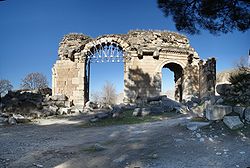
A Roman-period triumphal arch at
Anazarbus
, later converted into the
city’s south gate
Cilicia Trachea became the haunt of pirates, who were subdued by
Pompey
in 67 BC following a
Battle of Korakesion
(modern
Alanya
), and Tarsus was made the capital of the
Roman province
of Cilicia. Cilicia Pedias
became Roman territory in 103 BC first conquered by
Marcus Antonius Orator
in his campaign against
pirates, with
Sulla
acting as its first governor, foiling an
invasion of
Mithridates
, and the whole was organized by
Pompey
, 64 BC, into a province which, for a
short time, extended to and included part of
Phrygia
.
It was reorganized by
Julius Caesar
, 47 BC, and about 27 BC became
part of the province Syria-Cilicia Phoenice. At first the western district was
left independent under native kings or priest-dynasts, and a small kingdom,
under
Tarcondimotus I
, was left in the east; but
these were finally united to the province by
Vespasian
, AD 72. Containing 47 known cities,
it had been deemed important enough to be governed by a
proconsul
.
Under Emperor Diocletian’s
Tetrarchy
(c. 297), Cilicia was governed by a
consularis
; with Isauria and the Syrian,
Mesopotamian, Egyptian and Libyan provinces, formed the
Diocesis Orientis
(in the late 4th century the
African component was split off as
Diocese of Egypt
), part of the
Orienspretorian prefecture also called
(‘the East’, also including the
dioceses of
Asiana
and
Pontica
, both in Anatolia, and
Thraciae
in the Balkans), the rich bulk of the
eastern Roman Empire
.
Roman Cilicia exported the goats-hair cloth, Cilicium, which was used
to make tents. Tarsus was also the birthplace of the early
Christian missionary
and author
St. Paul
, writer (or purported writer) of 13 of
the 27 books included in the
New Testament
.
Cilicia had numerous Christian communities and is mentioned six times in the
Book of Acts
and once in the
Epistle to the Galatians
(1:21). After
Christianity became the official religion of the Roman Empire in the 4th
century, Cilicia was included in the territories of the patriarchate of Antioch.
The region was divided into two civil and ecclesiastical provinces: Cilicia
Prima, with a
metropolitan diocese
at
Tarsus
and
suffragan dioceses
for
Pompeiopolis
,
Sebaste
,
Augusta
,
Corycus
,
Adana
,
Mallus
and
Zephyrium
; and Cilicia Secunda, with a
metropolitan diocese at
Anazarbus
and suffragan dioceses for Mopsuestia,
Aegae
,
Epiphania
,
Irenopolis
,
Flavias
,
Castabala
,
Alexandria
,
Citidiopolis
and
Rhosus
. Bishops from the various dioceses of
Cilicia were well represented at the
First Council of Nicaea
in 325 and at the later
ecumenical councils.
After the breakup of the Roman Empire Cilicia became part of the Byzantine
Empire.
In the 7th century Cilicia was invaded by the Muslim Arabs. The area was for
some time an embattled no-man’s land. The Arabs succeeded in conquering the area
in the early 8th century. Under the
Abbasid Caliphate
, Cilicia was resettled and
transformed into a fortified frontier zone (thughur).
Tarsus, re-built in 787/788, quickly became the largest settlement in the region
and the Arabs’ most important base in their raids across the Taurus Mountains
into Byzantine-held Asia Minor.
The Muslims held the country until it was reoccupied by the Emperor
Nicephorus II
in a series of campaigns in
962–965. From this period onward, the area increasingly came to be settled by
Armenians, especially as Imperial rule pushed deeper into the Caucasus over the
course of the 11th century.
Armenian Kingdom
Main article:
Armenian Kingdom of Cilicia
The Kingdom of Cilician Armenia, 1199–1375.
During the time of the
Crusades
, the area was controlled by the
Armenian Kingdom of Cilicia. The
Seljuk Turkish
invasions of Armenia were
followed by an exodus of Armenians migrating westward into the Byzantine Empire,
and in 1080
Ruben
, a relative of the last king of
Ani
, founded in the heart of the Cilician
Taurus a small principality which gradually expanded into the Armenian kingdom
of Cilicia. This Christian state, surrounded by Muslim states hostile to its
existence, had a stormy history of about 300 years, giving valuable support to
the crusaders, and trading with the great commercial cities of Italy.
Gosdantin
(r. 1095 – c. 1100) assisted the
crusaders on their march to Antioch, and was created knight and marquis.
Thoros I
(r. c. 1100 – 1129), in alliance with
the Christian princes of Syria, waged successful wars against the Byzantines and
Seljuk Turks.
Levond II
(Leo the Great (r. 1187–1219)),
extended the kingdom beyond
Mount Taurus
and established the capital at
Sis
. He assisted the crusaders, was crowned
King by the
Archbishop of Mainz
, and married one of the
Lusignans
of the crusader kingdom Cyprus.
Hetoum I
(r. 1226–1270) made an alliance with
the Mongols
, sending his brother
Sempad
to the Mongol court to submit in person.
The Mongols then assisted with the protection of Cilicia from the
Mamluks
of Egypt, until the Mongols themselves
converted to Islam. When
Levond V
died (1342), John of Lusignan was
crowned king as
Gosdantin IV
; but he and his successors
alienated the native Armenians by attempting to make them conform to the Roman
Church, and by giving all posts of honor to Latins, until at last the kingdom,
falling prey to internal dissensions, succumbed in 1375 to the attacks of the
Egyptian Mamluks.
Cilicia Trachea was conquered by the
Ottomans
in the 15th century, but Cilicia
Pedias remained independent until 1515.[citation
needed]
See also:
List of monarchs of the Armenian Kingdom of Cilicia
Ottoman Empire
Further information:
Ottoman Empire
In the 15th century, Cilicia fell under
Ottoman
dominion and officially became known as
the Adana Vilayet
. Cilicia was one of the most
important regions for the Ottoman Armenians because it managed very well to
preserve Armenian character throughout the years. In fact, the Cilician
highlands were densely populated by Armenian peasants in small but prosperous
towns and villages such as
Hadjin
and
Zeitun
, two mountainous areas where autonomy
was maintained until the 19th century. In ports and cities of the Adana plain,
commerce and industry were almost entirely in the hands of the Armenians and
they remained so thanks to a constant influx of Armenians from the highlands.
Their population was continuously increasing in numbers in Cilicia in contrast
to other parts of the Ottoman Empire, where it was, since 1878, decreasing due
to repression. This is true despite the fact that in 1909, Armenians were
subjected to a
massacre in Adana
. During the 1915
Armenian genocide
, the Armenians of Zeitun had
organized a successful resistance against the Turkish onslaught. In order to
finally subjugate Zeitun, the Turks had to resort to treachery by forcing an
Armenian delegation from Marash to ask the Zeituntsi-s to put down their
arms. Both the Armenian delegation, and later, the inhabitants of Zeitun, were
left with no choice.
From December 1918 to October 1921, after the defeat of the Ottoman Empire in
World War I, the French controlled Cilicia. According to the
Treaty of Sèvres
signed in 1920, Cilicia was to
become an independent Armenian state under French authority. That treaty never
went into effect because of the
Turkish War of Independence
. Measures were
taken to repopulate the region with Armenians. More than 170,000 refugees, the
majority of whom were originally from Cilicia, were to be taken back to their
homes by the French and British. The Armenians formed the
Armenian National Union
which acted as an
unofficial Cilician Armenian government composed of the four major political
parties and three Armenian religious denominations. However, rivalries between
the French and British and
Kemalist
incursions shattered Armenian
aspirations for an autonomous Cilicia. On October 21, 1921, France signed the
Treaty of Ankara
with the Kemalist
revolutionaries and relinquished Cilicia to Turkey.
Republic of Turkey
Further information:
Franco-Turkish War
,
Republic of Turkey
After the Franco-Turkish War and consequent battles during
Turkish War of Independence
, the region become
part of the Republic of Turkey
in 1921 with the signing of
the
Treaty of Lausanne
. The modern Turkish
provinces
Mersin
,
Adana
, and
Osmaniye
are located in former Cilicia.
Mythological namesake
Greek mythology
mentions another Cilicia,
as a small region situated immediately southeast of the
Troad
in northwestern Asia Minor, facing the
Gulf of Adramyttium
. The connection (if any)
between this Cilicia and the better-known and well-defined region mentioned
above is unclear. This Trojan Cilicia is mentioned in
Homer
‘s Iliad and
Strabo
‘s Geography, and contained
localities such as
Thebe
,
Lyrnessus
and
Chryse
[disambiguation
needed]. These three cities were all attacked and
sacked by Achilles
during the
Trojan War
.
In
Prometheus Bound
(v 353),
Aeschylus
mentions the Cilician caves, where
the earth-born, hundred-headed monster
Typhon
dwelt before he withstood the gods and
was stricken and charred by
Zeus‘s thunderbolt.
See also
|


.JPG/300px-0_La_Bataille_d'Issus_-_Jan_Brueghel_l'Ancien_(détail).JPG)